Water
Mapping the World’s River Basins by Continent
Article/Editing:
There are hundreds of rivers on Earth’s surface, moving freshwater from hills and mountains down to larger rivers, lakes, and oceans.
Thanks to the planet’s natural slopes and ridges, falling rain that isn’t absorbed by soil or evaporated also ends up in nearby rivers. This area—where all flowing surface water converges—is called a river basin, drainage basin, or watershed.
These maps by Adam Symington show the world’s many rivers and major river basins, using the HydroSHEDS database and broken down by continent.
Mapping River Basins By Continent
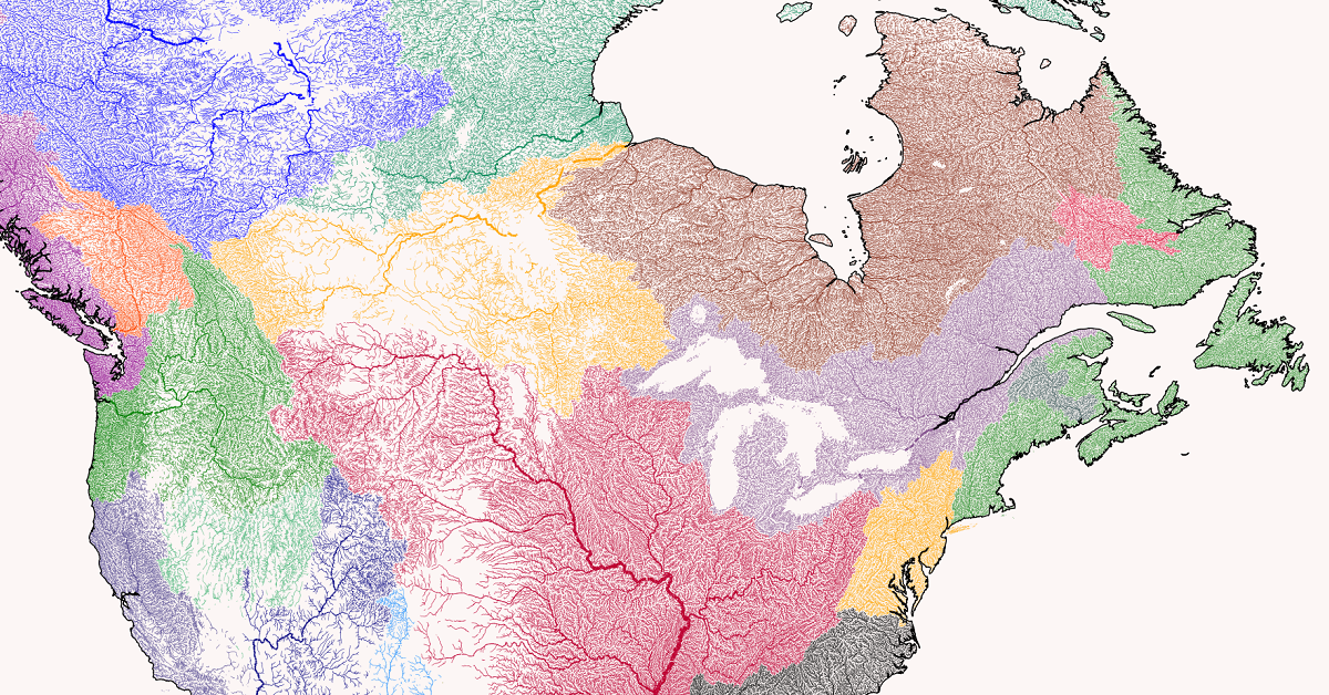
The Americas
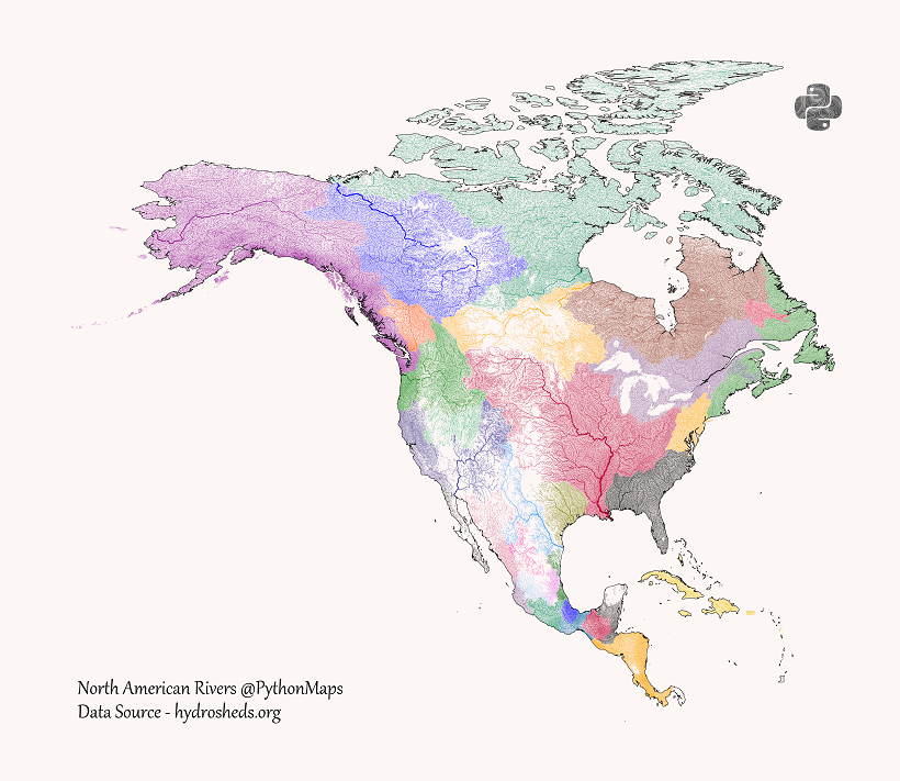
North and Central America have many different river basins, but a few major rivers stand out.
To the North, Canada’s Mackenzie River runs from British Columbia through the Northwest Territories and ending up at the Arctic Ocean.
Of course, the Mississippi River and the Missouri River which flows into it both stand out as well, draining water from much of the U.S. to the Gulf of Mexico.
A few rivers and basins also start in the U.S. and end up in Mexico, including the Rio Grande from Colorado to Tamaulipas. Further south in Central America and the Caribbean, most of the basins don’t have major rivers and empty into the nearby oceans.
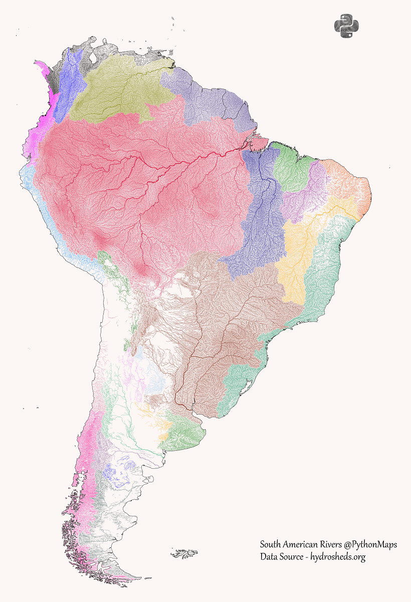
It’s well-known that the Amazon River is the largest river in the world by volume and the second largest by length.
Likewise, its reach and impact can be seen in these maps. The Amazon basin is the largest river basin in the world with an area of 6,300,000 km², covering just over one-third of the entire South American continent.
That is almost double the sizable Río de la Plata basin, the 5th largest river basin in the world, which includes the Uruguay River and the Paraná River and meets at the border between Uruguay and Argentina.
Europe and Africa
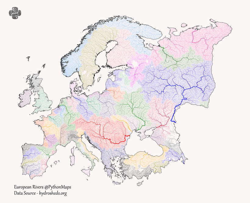
Despite being the second smallest continent, Europe’s proximity to many different bodies of water and great variation of terrain in small areas gives it many different drainage basins.
But a few notable rivers stand out in Central and Eastern Europe. The Danube, a historically important trade route and once a frontier of the Roman Empire, originates in Germany and flows eastwards to the Black Sea, passing through 10 total countries.
The longest river in Europe, the Volga in Russia, is also the cornerstone of the continent’s largest river basin, draining into the Caspian Sea. Its tributaries include the Moskva which runs through Moscow in Western Russia before flowing eastwards.
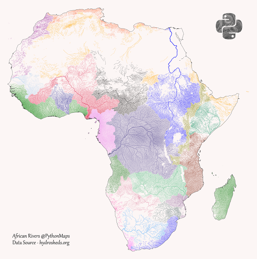
One of Africa’s most notable features is the lack of drainage in the Sahara Desert. But the continent also has a few clear major river systems, including two of the world’s largest rivers.
In the northeast, the Nile River is the world’s longest river, flowing from Lake Victoria and Lake Tana in the south to Egypt and the Mediterranean Sea. In total, its basin covers 11 countries.
In Central Africa, the Congo River (formerly the Zaire River) is the second largest river in the world by volume. It also is central to the Congo Basin, the second largest river basin with an area of 4,014,500 km².
And in West Africa, the Niger River creates a crescent shaped basin from the Guinea Highlands, northeast to Mali, then southwest through Niger and Nigeria. It ends in the massive (and massively important and populated) Niger Delta.
Asia and Oceania
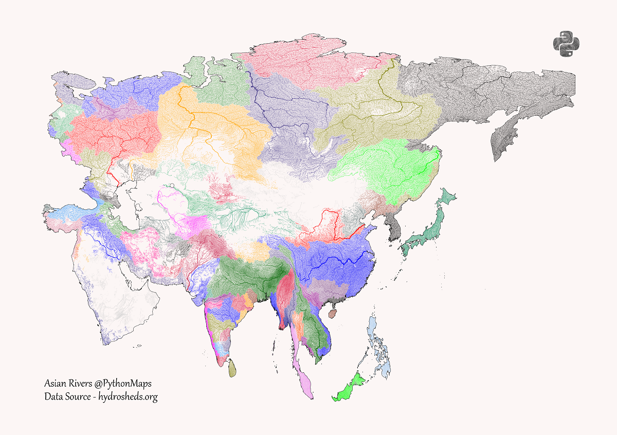
The world’s largest continent also has one of the largest varieties of river basins. From large sweeping basins in North Asia, to deserts in mountainous Central Asia and the Arabian Peninsula, to the multitude of basins draining into the Indian Ocean.
One of the major standouts is the Yangtze in China, the world’s third-longest river and largest plastic emitting river. Flowing from the Tibetan Plateau to the East China Sea, its wide basin covers one-fifth of China’s land area and one-third of its population.
The largest by volume is the Ganges–Brahmaputra–Meghna system, three major rivers running through India, China, Nepal, and Bangladesh. Their combined basin is home to around 400 million people, making it the most populous river basin in the world, ultimately draining into the Ganges Delta and ending up at the Bay of Bengal.
But the largest river basins in Asia are those of the “great Siberian rivers,” the Ob, the Yenisei, and the Lena, which all flow north to the Arctic Ocean.
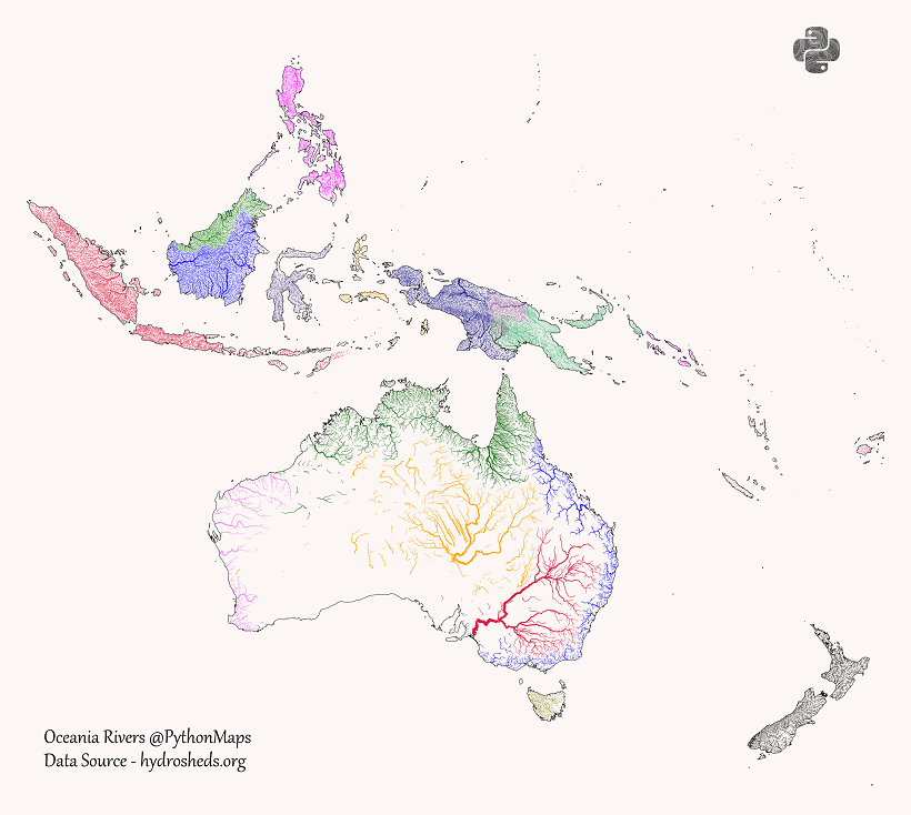
Comprised of many archipelagos and islands with a high ratio of coast along the Pacific Ocean, Oceania understandably has fewer long rivers and major river basins.
But there are still a few standouts, especially in the deserts of Australia. The Murray–Darling basin in the country’s southeast includes six of Australia’s seven longest rivers (including the namesake Murray), draining west to the Southern Ocean near Adelaide.
Towards the center of the country is the Lake Eyre basin, which covers 1,210,000 km² or just under one-sixth of the country’s landmass. This mostly flat and often dry basin drains into Lake Eyre, Australia’s largest lake, which only fills up with water about four times a century.
If you want to see higher resolution versions of these maps and do more river exploration for yourself, head to the PythonMaps Twitter. For full-size prints, check out the PythonMaps Etsy.

This article was published as a part of Visual Capitalist's Creator Program, which features data-driven visuals from some of our favorite Creators around the world.


Water
Animated Map: Where to Find Water on Mars
This new planet-wide animated map, based on a decade of space agency research, shows where water can be found on Mars.
Animation: New Water Map of Mars
The hunt for water on Mars has always been a point of interest for researchers.
Earth has life almost everywhere water exists. Water is an ideal target for finding lifeforms, like microbes, that may exist on other planets.
And if Mars is to become a future home, knowing where water exists will be necessary for our survival.
Both NASA and the European Space Agency (ESA) have special instruments searching for water on the red planet. After 10 years of in-depth investigation, their latest findings suggest a new “water map” for Mars.
Where Did the Water Go?
Many people know Mars as a dry and dusty planet, but it hasn’t always been that way.
Approximately 4.1 to 3.8 billion years ago, Mars had a massive ocean called Oceanus Borealis. It dominated the northern hemisphere of the planet. Specific planetary conditions at that time let water exist on its surface. Changes in temperature, climate, and geology over the years gradually pushed water out to the atmosphere or into the ground.
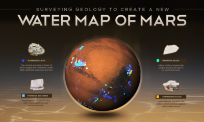
Up to 99% of this ocean water is trapped within the planet’s crust, locked within special rocks called hydrous minerals.
Hydrous Minerals
Hydrous minerals are essentially rocks that have water (or its two main elements, hydrogen and oxygen), incorporated into their chemical structure.
There are four main classes of hydrous minerals: silicates, sulfates, silicas, and carbonates. While these minerals look pretty similar to the naked eye, their chemical compositions and structural arrangements vary. They are detectable by sophisticated equipment and can tell scientists how water geologically changes over time.
The new water map of Mars actually highlights the location of these hydrous minerals. It is a geological map of the rocks that are holding what remains of Mars’s ancient ocean.
Other Sources of Water on Mars
Despite being a “graveyard” for the bulk of the planet’s ocean, hydrous minerals are not the only source of water on Mars.
Water ice is present at both of Mars’s poles. The northern polar ice cap contains the only visible water on the planet, while the southern pole covers its water with a frozen carbon-dioxide cap.
In 2020, radar analyses suggested the presence of liquid water, potentially part of a network of underground saltwater lakes, close to the southern pole. In 2022, new evidence for this liquid water suggested that the planet may still be geothermally active.
More frozen water may be locked away in the deep subsurface, far below what current surveying equipment is able to inspect.
Mapping Out the Next Missions
The new water map is highlighting areas of interest for future exploration on Mars.
There is a small chance that hydrous minerals may be actively forming near water sources. Finding where they co-exist with known areas of buried frozen water provides possible opportunities for extracting water.
ESA’s Rosalind Franklin Rover will land in Oxia Planum, a region rich in hydrous clays, to investigate how water shaped the region and whether life once began on Mars.
Many more investigations and studies are developing, but for now, scientists are just getting their toes wet as they explore what hydrous minerals can tell us of Mars’s watery past.
-
 Energy3 weeks ago
How Old Are the World’s Nuclear Reactors?
-
 Countries7 days ago
Mapped: World’s Top 40 Largest Military Budgets
-
 Markets3 weeks ago
How Big is the Market for Crude Oil?
-

 Crime6 days ago
Mapped: The Safest Cities in the U.S.
-

 Markets2 weeks ago
Ranked: The Most Profitable U.S. Companies, by Sector
-

 apps5 days ago
How Long it Took for Popular Apps to Reach 100 Million Users
-

 Markets4 weeks ago
The World’s Biggest Mutual Fund and ETF Providers
-

 Brands2 weeks ago
Brand Reputations: Ranking the Best and Worst in 2023