History
Mapping the World’s Overseas Territories and Dependencies
Article/Editing:
View a higher resolution version of this graphic.

Overseas Territories and Dependencies of the World
An overseas territory or dependency is a region with ties abroad to a sovereign nation—not a completely independent state, but also not a constituent part or administrative subdivision of the parent country.
Their histories vary, but most are tied to either “modern” colonialism from the 1400s onwards, or wars from the 19th and 20th centuries. Many of these regions still depend on their parent country to some capacity for economic, military, and diplomatic affairs.
This graphic by Pranav Gavali maps the overseas territories of various countries, using a variety of sources including WorldAtlas, Statista, and official country releases.
Where are the World’s Overseas Territories and Dependencies?
There are a total of 71 overseas territories listed on the map spread across the world.
It excludes territories claims in Antarctica, which are currently governed by the 1959 Antarctic Treaty. As an overseas map, it also excludes territories sharing a border, or that are part of a larger state or province (like Germany’s Heligoland, part of the state of Schleswig-Holstein).
Each region has its own unique present-day status. Some are “autonomous territories” or “constituent countries,” while some are administered almost entirely as part of the parent country.
| Sovereign | Overseas Territory / Dependency | Region |
|---|---|---|
| 🇦🇺 Australia | Ashmore and Cartier Islands | Indian Ocean |
| 🇦🇺 Australia | Christmas Island | Indian Ocean |
| 🇦🇺 Australia | Cocos (Keeling) Islands | Indian Ocean |
| 🇦🇺 Australia | Coral Sea Islands | Pacific Ocean |
| 🇦🇺 Australia | Heard & McDonald Islands | Indian Ocean |
| 🇦🇺 Australia | Norfolk Island | Pacific Ocean |
| 🇩🇰 Denmark | Faroe Islands | Atlantic Ocean |
| 🇩🇰 Denmark | Greenland | Atlantic Ocean / Arctic Ocean |
| 🇫🇷 France | Bassas da India | Indian Ocean |
| 🇫🇷 France | Clipperton Island | Pacific Ocean |
| 🇫🇷 France | Europa Island | Indian Ocean |
| 🇫🇷 France | French Guiana | South America |
| 🇫🇷 France | French Polynesia | Pacific Ocean |
| 🇫🇷 France | Glorioso Islands | Indian Ocean |
| 🇫🇷 France | Guadeloupe | Caribbean |
| 🇫🇷 France | Juan de Nova Island | Indian Ocean |
| 🇫🇷 France | Martinique | Caribbean |
| 🇫🇷 France | Mayotte | Indian Ocean |
| 🇫🇷 France | New Caledonia | Pacific Ocean |
| 🇫🇷 France | Réunion | Indian Ocean |
| 🇫🇷 France | Saint Barthélemy | Caribbean |
| 🇫🇷 France | Saint Pierre and Miquelon | Atlantic Ocean |
| 🇫🇷 France | Saint-Martin | Caribbean |
| 🇫🇷 France | Tromelin Island | Indian Ocean |
| 🇫🇷 France | Wallis and Futuna | Pacific Ocean |
| 🇳🇱 Netherlands | Aruba | Caribbean |
| 🇳🇱 Netherlands | Bonaire | Caribbean |
| 🇳🇱 Netherlands | Curaçao | Caribbean |
| 🇳🇱 Netherlands | Saba | Caribbean |
| 🇳🇱 Netherlands | Sint Eustatius | Caribbean |
| 🇳🇱 Netherlands | Sint Maarten | Caribbean |
| 🇳🇿 New Zealand | Cook Islands | Pacific Ocean |
| 🇳🇿 New Zealand | Niue | Pacific Ocean |
| 🇳🇿 New Zealand | Tokelau | Pacific Ocean |
| 🇳🇴 Norway | Bouvet Island | Atlantic Ocean |
| 🇳🇴 Norway | Jan Mayen | Arctic Ocean |
| 🇳🇴 Norway | Peter I Island | Southern Ocean |
| 🇳🇴 Norway | Svalbard | Arctic Ocean |
| 🇵🇹 Portugal | Azores | Atlantic Ocean |
| 🇵🇹 Portugal | Madeira | Atlantic Ocean |
| 🇬🇧 United Kingdom | Akrotiri (British Forces) | Cyprus / Mediterranean |
| 🇬🇧 United Kingdom | Anguilla | Caribbean |
| 🇬🇧 United Kingdom | Bermuda | Atlantic Ocean |
| 🇬🇧 United Kingdom | British Indian Ocean Territory | Indian Ocean |
| 🇬🇧 United Kingdom | British Virgin Islands | Caribbean |
| 🇬🇧 United Kingdom | Cayman Islands | Caribbean |
| 🇬🇧 United Kingdom | Dhekelia (British Forces) | Cyprus / Mediterranean |
| 🇬🇧 United Kingdom | Falkland Islands (Islas Malvinas) | Atlantic Ocean |
| 🇬🇧 United Kingdom | Gibraltar | Europe |
| 🇬🇧 United Kingdom | Guernsey (Channel Island) | Atlantic Ocean |
| 🇬🇧 United Kingdom | Isle of Man | Atlantic Ocean |
| 🇬🇧 United Kingdom | Jersey (Channel Island) | Atlantic Ocean |
| 🇬🇧 United Kingdom | Montserrat | Caribbean |
| 🇬🇧 United Kingdom | Pitcairn, Henderson, Ducie & Oeno Islands | Pacific Ocean |
| 🇬🇧 United Kingdom | Saint Helena, Ascension & Tristan da cunha | Atlantic Ocean |
| 🇬🇧 United Kingdom | South Georgia & South Sandwich Islands | Atlantic Ocean |
| 🇬🇧 United Kingdom | Turks & Caicos Islands | Caribbean |
| 🇺🇸 United States | American Samoa | Pacific Ocean |
| 🇺🇸 United States | Baker Island | Pacific Ocean |
| 🇺🇸 United States | Guam | Pacific Ocean |
| 🇺🇸 United States | Howland Island | Pacific Ocean |
| 🇺🇸 United States | Jarvis Island | Pacific Ocean |
| 🇺🇸 United States | Johnston Atoll | Pacific Ocean |
| 🇺🇸 United States | Kingman Reef | Pacific Ocean |
| 🇺🇸 United States | Midway Islands / Atoll | Pacific Ocean |
| 🇺🇸 United States | Navassa Island | Caribbean |
| 🇺🇸 United States | Northern Mariana Islands | Pacific Ocean |
| 🇺🇸 United States | Palmyra Atoll | Pacific Ocean |
| 🇺🇸 United States | Puerto Rico | Caribbean |
| 🇺🇸 United States | U.S. Virgin Islands | Caribbean |
| 🇺🇸 United States | Wake Island | Pacific Ocean |
More than half of the overseas territories were in either the Pacific Ocean (21) or the Caribbean (18). The United States by itself accounts for 11 of the territories spread out across the North and South Pacific.
Another highlight is that the majority of these regions are islands located quite a distance from their parent countries. One of the furthest is New Caledonia, a French territory around 17,000 km away from European France.
They also vary mightily in terms of size, population, and political apparatus. For example, the U.S. territory of Puerto Rico has 3 million people, and its own constitution and elected government, while another U.S. territory of Johnston Atoll is tiny and entirely uninhabited.
Here’s a brief look at some of the best known territories on the list:
Guam
First colonized by Spain in the 16th century, the U.S. occupied the North Pacific islands in the aftermath of the Spanish–American war (along with Puerto Rico and the Philippines). The island was briefly occupied by Japan during World War II—attacked at the same time as Pearl Harbor—before being recaptured by the United States. It currently has an elected legislature and governor and is home to a large U.S. military base.
Bermuda
When Bermuda was first discovered in the 1500s by the Spanish in the Caribbean, and then a century later by the English, there was no Indigenous population documented. At first it was used by passing ships as a replenishment spot, but the English eventually settled it in the 17th century. It now has a constitution, a parliament, and a governor who exercises power on behalf of the British head of state.
Cook Islands
Unlike others on this list, the Cook Islands in the South Pacific is not only self-governing but also runs its own foreign and defense policy and is in “free association” with New Zealand. While Cook Islanders are New Zealand citizens, with the same monarch as head of state, they are also separate Cook Island nationals.
Réunion
This island in the Indian Ocean 700 km off the coast of Madagascar was first settled by the French in the 17th century, though it was discovered earlier by the Portuguese. It is one of the many French Overseas Territories that together are home to 2.6 million people.
Countries With the Most Overseas Territories and Dependencies
Depending on if you count island territories independently or group them together, the final accounting of overseas territories and dependencies by country can vary.
But by most official designations of territories, the UK and France are tied with 17 overseas territories.
| Country | Overseas Territories & Dependences |
|---|---|
| 🇫🇷 France | 17 |
| 🇬🇧 United Kingdom | 17 |
| 🇺🇸 United States | 14 |
| 🇦🇺 Australia | 6 |
| 🇳🇱 Netherlands | 6 |
| 🇳🇴 Norway | 4 |
| 🇳🇿 New Zealand | 3 |
| 🇩🇰 Denmark | 2 |
| 🇵🇹 Portugal | 2 |
Unsurprisingly, two great empires of the past—Britian and France—still have largest remnants of their past breadth. The British still maintain many ties to several territories in the Caribbean (formerly the British West Indies) while French influence stretches from the Pacific to South America.
And consider that this list reflects current status as of 2023. Former colonies that would have been counted in the past include British India (which became India, Pakistan, and Bangladesh) and French Indochina (which became Cambodia, Laos, and Vietnam).
As for the U.S. at #3, though the majority of its territories are in the Pacific, they were acquired well before World War II. In addition to islands ceded by Spain, the rest were unclaimed islands incorporated as part of the Guano Islands Act of 1856, which sought sources of guano—feces of bats and seabirds used as agricultural fertilizer and for gunpowder production.
Editor’s note: The original graphic and article included a source which had incorrect sizes and listed Spain as having two territories. The graphic, article, and relevant tables and overall numbers have been updated.

This article was published as a part of Visual Capitalist's Creator Program, which features data-driven visuals from some of our favorite Creators around the world.


Maps
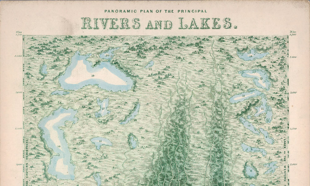
Vintage Viz: The World’s Rivers and Lakes, Organized Neatly
Rivers and lakes have played important roles throughout history. This Vintage Viz looks at these bodies of water from the viewpoint of 1850.
Vintage Viz: The World’s Rivers and Lakes, Organized Neatly
Rivers and lakes have borne witness to many of humanity’s greatest moments.
In the first century BCE, the Rubicon not only marked the border between the Roman provinces of Gaul and Italia, but also the threshold for civil war. From the shores of Lake Van in 1071, you could witness the Battle of Manzikert and the beginning of the end for the Byzantine Empire.
Rivers carry our trade, our dead, and even our prayers, so when London mapmaker James Reynolds partnered with engraver John Emslie to publish the Panoramic Plan of the Principal Rivers and Lakes in 1850, he could be sure of a warm reception.
The visualization, the latest in our Vintage Viz series, beautifully illustrates 42 principal rivers in Europe, Asia, Africa, and the Americas, along with 36 lakes across the Eastern and Western hemispheres. Each river has been unraveled and straightened onto an imaginary landscape-–no meandering here—and arranged by size. Major cities are marked by a deep orangy-red.
Top 3 Longest Principal Rivers (in 1850)
According to this visualization, the Mighty Mississippi is among the world’s longest, coming in at 3,650 miles, followed by the Amazon, the Nile, and the Yangtze river in China. The bottom three are the Tay in Scotland (125 miles), the Shannon in Ireland (200 miles), and the Potomac in the U.S. (275 miles).
Surveying methods have come a long way since 1850, and we now have satellites, GPS, and lasers, so we can update these rankings. According to the CIA World Factbook, the Nile (6,650 km / 4,132 miles), the Amazon (6,436 km / 3,998 miles), and the Yangtze (6,300 km / 3,915 miles) are the world’s top three longest rivers.
The table below shows the rivers in the graphic above compared with today’s measurements, as well as the general location of rivers using 1850 location names (including modern day locations in brackets).
| River | Territory | Viz length (miles) | Modern length (miles) |
|---|---|---|---|
| Mississippi | United States | 3,650 | 2,340 |
| Amazon | Brazil | 3,350 | 3,998 |
| Nile | Egypt and Abyssinia (Ethiopia) | 3,325 | 4,132 |
| Yangtse | China | 3,300 | 3,915 |
| Hoang-ho | China | 3,025 | 3,395 |
| Obi | Siberia | 2,800 | 2,268 |
| La Plata | La Plata (Argentina/Uruguay) | 2,450 | 3,030 |
| Volga | Russia | 2,200 | 2,193 |
| Burrampoota | Tibet | 2,200 | 1,800 |
| Ganges | Hindostan (India) | 1,975 | 1,569 |
| Euphrates | A(siatic) Turkey | 1,850 | 1,740 |
| Danube | Germany | 1,800 | 1,770 |
| Niger | Nigeria | 1,750 | 2,600 |
| Indus | Caubul etc (Afghanistan etc) | 1,700 | 1,988 |
| McKenzie | Indian Territory (Canada) | 1,600 | 1,080 |
| Senegal | Senegambia (Senegal) | 1,450 | 1,020 |
| Dnieper | Russia | 1,375 | 1,367 |
| Oronoco | Gran Colombia (Venezuela) | 1,325 | 1,700 |
| Gambia | Senegambia (The Gambia) | 1,300 | 740 |
| Bravo del Norta (Rio Grande) | Mexico | 1,150 | 1,900 |
| St. Lawrence | Canada | 1,125 | 1,900 |
| Orange | Namaqualand (Namibia/South Africa) | 1,100 | 1,367 |
| Dwina | Russia | 1,000 | 1,020 |
| Don | Russia | 975 | 1,198 |
| Rhine | Germany | 850 | 766 |
| Elbe | Germany | 750 | 724 |
| Vistula | Poland | 650 | 651 |
| Oder | Prussia (Germany) | 625 | 529 |
| Colorando | La Plato (United States) | 600 | 1,450 |
| Tague | Spain and Portugal | 575 | 626 |
| Susquehana | United States | 575 | 464 |
| Rhone | France | 550 | 505 |
| Seine | France | 475 | 485 |
| Po | North Italy | 450 | 405 |
| Hudson | United States | 425 | 315 |
| Ebro | Spain | 400 | 565 |
| Severn | England | 350 | 220 |
| Delaware | United States | 325 | 301 |
| Potomac | United States | 275 | 405 |
| Thames | England | 275 | 215 |
| Shannon | Ireland | 200 | 224 |
| Tay | Scotland | 125 | 117 |
These figures are a unique look into a time period where humanity’s efforts to quantify the world were still very much a work in progress.
Editor’s note: Some of the rivers and lakes are spelled slightly differently in 1850 than they are today. For example, the map notes today’s Mackenzie River (Canada) as the McKenzie River, and the Yangtze River (China) as the Yangtse.
O Say, Can You Sea?
The largest ‘lake’ in this visualization is the Caspian Sea (118,000 sq. miles), followed by the Black Sea (113,000 sq. miles), and the greatest of the Great Lakes, Lake Superior (22,400 sq. miles). While the Caspian Sea is considered a saltwater lake and could reasonably have a place here, the Black Sea—possibly bearing that name because of the color black’s association with “north”—is not a lake by any stretch of the imagination.
And while many of the surface areas reported could also be updated with modern estimates, the story behind Lake Chad (called Ichad in the visualization), the Aral Sea, and the Dead Sea are altogether different. Human development, unsustainable water use, and climate change have led to dramatic drops in water levels.
The Dead Sea in particular had a surface area of 405 sq. miles (1,050 km2) in 1930, but has since dropped to 234 sq. miles (606.1 km2) in 2016.
| Lake | Territory | Viz surface area (sq. miles) | Modern surface area (sq. miles) |
|---|---|---|---|
| Caspian Sea | Russia | 118,000 | 143,000 |
| Black Sea | Turkey | 113,000 | 168,500 |
| Superior | North America | 22,400 | 31,700 |
| Huron | North America | 15,800 | 23,007 |
| Michigan | North America | 12,600 | 22,404 |
| Great Slave | North America | 12,000 | 10,500 |
| Aral Sea | Tartary (Central Eurasia) | 11,650 | 6,900 |
| Ichad | Africa | 11,600 | 590 |
| Azov | Russia | 8,800 | 14,500 |
| Baikal Sea | Siberia | 8,000 | 12,248 |
| Winnepeg | North America | 7,200 | 9,416 |
| Maracaibo | South America | 6,000 | 5,130 |
| Titicaca | South America | 5,400 | 3,030 |
| Ladoga | Russia | 5,200 | 6,700 |
| Balkash | Mongolia | 5,200 | 7,000 |
| Erie | North America | 4,800 | 9,910 |
| Ontario | North America | 4,450 | 7,340 |
| Great Bear | North America | 4,000 | 12,028 |
| Orega | Russia | 3,300 | 3,700 |
| Athabasca | North America | 3,200 | 3,030 |
| Nicaragua | North America | 2,905 | 3,149 |
| Otehenantekane | North America | 2,500 | 2,500 |
| Wener | Sweden | 2,100 | 2,181 |
| Winnepagos | North America | 2,000 | 2,070 |
| Zaizan | Mongolia | 1,600 | 700 |
| Dembia | Abyssinia (Ethiopia) | 1,300 | 1,418 |
| Tonting | China | 1,200 | 1,090 |
| Wetter | Sweden | 945 | 738 |
| Orebo | Sweden | 900 | 186 |
| Ouroomia | Persia | 900 | 1,126 |
| Enare | Lapland (Finland) | 870 | 1,040 |
| Constance | Scotland | 456 | 209 |
| Geneva | Swtizerland | 400 | 224 |
| Dead Sea | Syria | 370 | 605 |
| Lough Neagh | Ireland | 80 | 153 |
| Loch Lomond | Scotland | 27 | 27 |
You Can’t Step in the Same River Twice
Over time, natural and anthropogenic forces cause rivers to change their course, and lakes to shift their banks. If Reynolds and Emslie were alive today to update this visualization, it would likely look quite different, as would one made 100 years from now. But so goes the river of time.

-
 Environment5 days ago
Hotter Than Ever: 2023 Sets New Global Temperature Records
-

 Datastream4 weeks ago
Can You Calculate Your Daily Carbon Footprint?
-
 Energy2 weeks ago
Who’s Still Buying Russian Fossil Fuels in 2023?
-

 VC+4 days ago
What’s New on VC+ in July
-

 Investor Education4 weeks ago
Visualizing BlackRock’s Top Equity Holdings
-

 Technology2 weeks ago
Meet the Competing Apps Battling for Twitter’s Market Share
-

 Misc15 hours ago
How Do Chinese Citizens Feel About Other Countries?
-

 Markets4 weeks ago
Visualizing Every Company on the S&P 500 Index